STORY #3
Disaster prevention system for the safe evacuation of people in urban underground spaces wherepositioning is difficult
Nobuhiko Nishio
Professor, College of
Information Science and Engineering
How to discover an individual’s position in indoor areas where GPS cannot be relied upon
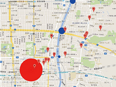
For the six months starting from September 2014, small devices to locate people's positions were installed in different places in underground shopping arcades in Osaka, Tokyo and Nagoya in order to conduct a demonstration test to assess the effectiveness of the “G-Space” Disaster Prevention System (G stands for “Geospatial information”). This experiment was one of Ritsumeikan University's projects that were adopted as a G-Space City Construction Project by the Ministry of Internal Affairs and Communications (MIC). Nobuhiko Nishio has been engaged in building a system that enables information transmission and evacuation guidance support in underground spaces from the viewpoint of disaster prevention by developing cutting-edge indoor positioning technology.
With the ever growing and widespread use of smartphones incorporating GPS (Global Positioning Systems), it is not difficult for people to find out where they are at the moment. Such G-space information (Geospatial Information) can be utilized to grasp the position and movement of affected people and to guide and evacuate them safely when a disaster strikes. The problem is that GPS cannot be used reliably indoors or underground as it cannot receive radio waves from satellites. Nishio is involved in developing a method to identify an individual’s position indoors without depending on GPS by integrating multiple indoor positioning systems.
"There are mainly two methods to locate indoor positions," he explains. "One is a method to estimate one's current position by using individual sensors incorporated in terminals like smartphones, while the other involves installing equipment to assist positioning on the facility side. Both have advantages and disadvantages, but neither is sufficient to properly measure a person’s indoor position. We therefore applied a hybrid positioning method integrating both."

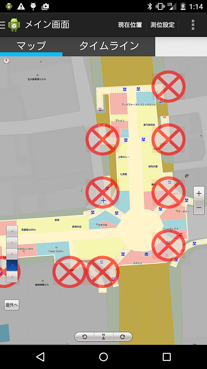
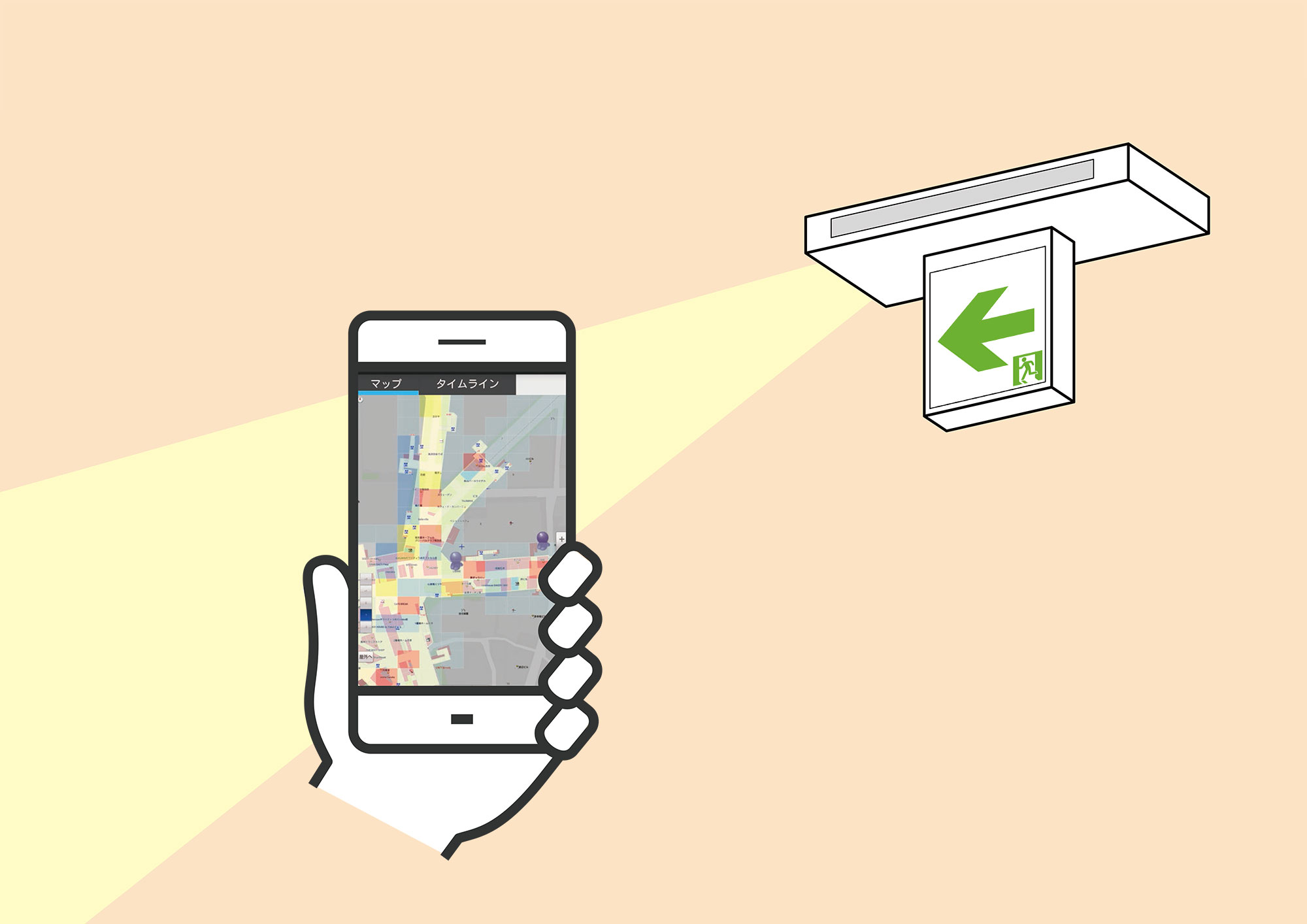
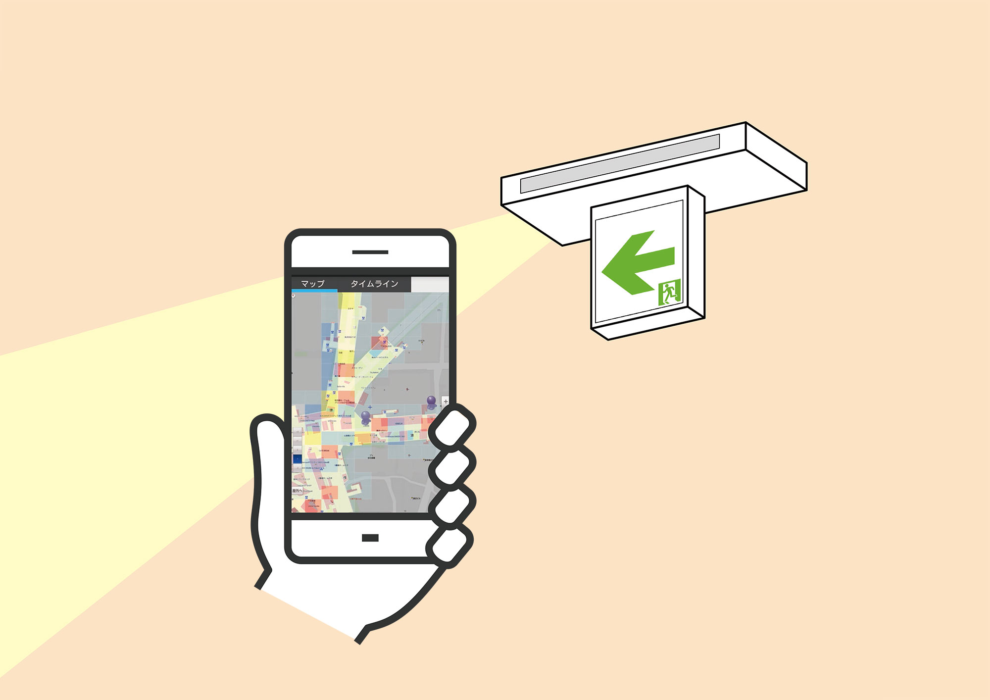
Conceptual drawing of B to B application carried by evacuation guidance personnel/In addition to one's current position and the positions of other guidance personnel, the people flow status acquired from the G-Space Guide Light system is displayed as a heat map. In addition, disaster information from a Disaster Response Headquarters can be displayed on a timeline.
Sensors incorporated in smartphone terminals include an acceleration sensor to detect acceleration in the directions of three axes, a gyroscope to measure rotation and an electronic compass to identify direction, where the locus of movement of the terminal holder is drawn. Furthermore, with a barometer, up and down movements can be estimated to an accuracy of about 1 m, enabling us to comprehend how people move in a three-dimensional underground space in a city.
We can understand relative movement, but we cannot learn the absolute position of where an individual is. One of the methods to enable this is to receive radio waves from Wi-Fi base stations that are installed in different places in underground shopping malls and then estimate the distance from the base station to the terminal. By integrating the radio wave information from multiple base stations, the absolute position of the smart phone terminal can be estimated with a high degree of accuracy. To yield sufficient accuracy, since Wi-Fi positioning has limitations, Nishio additionally installed compact-sized, energy-saving BLE devices (transmitters based on Bluetooth Low Energy standard) to transmit radio waves. Utilizing another MIC’s research grant result, he separately developed a technology that analyzes the people flow status by receiving radio waves from each terminal. By optimally combining these two technologies, it has become possible to estimate the position and movement of people in underground spaces more accurately and effectively.
As another challenge for this project, Nishio has developed applications to acquire and to distribute information that is necessary and effective for visitors and workers of underground shopping malls by taking advantage of the indoor positioning and people flow analysis technologies he has established. One is an application for general visitors to the facilities that is useful as a shopping and facility guide and even for sales promotions for facility managers during usual days, and the other is a business application for facility managers to make use of for evacuation guidance support at the time of a disaster.
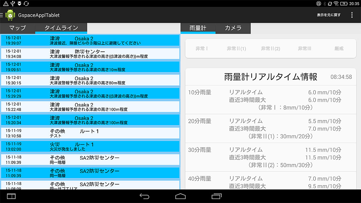
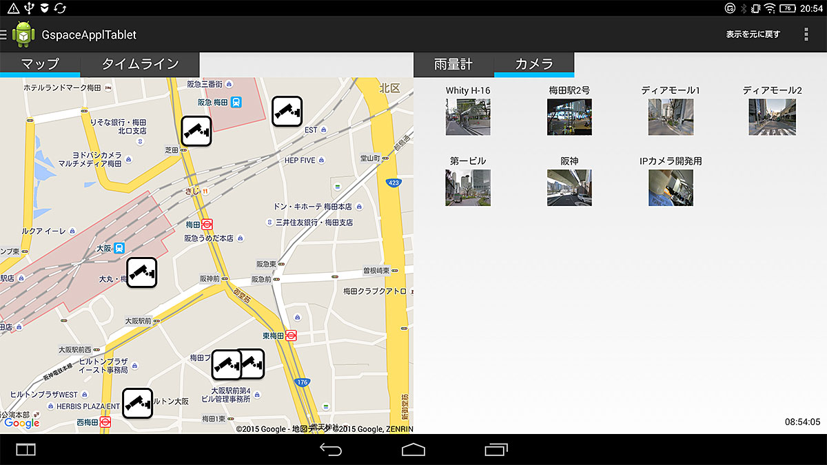
The latter is a system that is linked to the tablet terminals deployed at the disaster prevention center of individual facilities to integrate information. When a disaster occurs, information on the movement of visitors in underground shopping malls is integrated into the tablet at the disaster prevention center. Each disaster prevention center operates the tablet in order to distribute necessary information and instruction from the center to B to B applications (see right) carried by staff members. The B to B applications come equipped with a "timeline" function where the information and instructions are displayed one after another text line in addition to a "hazard map" function that draws the information on a map. In this way, he has developed a G-Space Disaster Prevention System for Underground Shopping Malls that combines indoor positioning technology in underground spaces with evacuation guidance support applications linked to each facility’s action plan during a disaster. As a result of the demonstration tests held at the three cities mentioned above, each has proved its effectiveness.
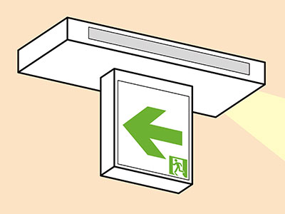
Also, in order to contribute to disaster prevention in a diverse range of indoor spaces, including buildings as well as underground shopping malls, Nishio has developed a G-Space Guide Light, which is a guide light that incorporates a G-space information device that transmits a variety of positioning radio waves and also estimates the people flow status. This has also been recognized for its effectiveness through a demonstration project carried out by the project. "Due to the barrier of the Fire Service Act, commercialization will take time, but going forward without a doubt it is expected to contribute to ICT implementation of Japanese firefighting facilities, firefighting and rescue activities and equipment for firefighters," he says.
In the second half of 2015, Nishio conducted his latest demonstration test in the city of Osaka. It was an attempt to coordinate the multiple disaster prevention centers of underground managers and have the G-Space Disaster Prevention System for Underground Shopping Malls works in a larger area than ever before. "When a disaster occurs, it will be meaningless if information can only be communicated in a single zone underground," he says. "Especially when a localized downpour of a short duration occurs and inundates the underground area, there is a risk that the inundation will spread over a wide area through connected facilities, buildings and subways. For this reason, a disaster prevention system that enables coordination beyond the scope of responsibility of a single facility manager is essential."
The Osaka municipal government established the Council on Underground Space Inundation Countermeasures and has been working on inundation simulations of underground shopping malls as a united effort with railway companies and underground shopping mall managers, and taking advantage of its achievements, Nishio has developed the G-Space Disaster Prevention System as a countermeasure against the inundation of underground shopping malls where multiple disaster prevention centers can work together. They plan to actually operate it at Osaka train station and Umeda train station areas in FY2016. The disaster prevention system developed by Nishio may well become the linchpin of disaster response measures in Japan in the future.
G-Space Guide Light system/The G-Space Guide Light system transmits radio waves to indicate absolute position information, enabling indoor positioning, and makes information on people flow status of the facility. The guide light is mounted with a battery in the event of a blackout, and with this integrated, continuous operation at the time of an emergency can be expected.
The G-Space Disaster Prevention System as a countermeasure against the inundation of underground shopping malls where multiple disaster prevention centers can work together
Nobuhiko Nishio
Professor, College of Information Science and Engineering
Subject of Research: Integration of real world information and information space
Research Keyword: Ubiquitous Computing, Sensing Networks, Location-based Information Systems